Mostrando entradas con la etiqueta social science. Mostrar todas las entradas

viernes, 26 de mayo de 2017

SOCIAL SCIENCE UNIT 7: TRAVEL AND ROAD SAFETY


CONTENIDOS:
-Principales medios de transporte y el medio por el que se mueven.
-Transporte público y transportes de uso privado.
-Las normas básicas de educación vial.
-Señales de tráfico más importantes: lectura y respeto por las mismas.

CRITERIOS DE EVALUACIÓN:

-Nombra algunos de los principales medios de transporte que circulan por tierra, agua y aire.
-Diferencia medios de transporte público y transportes privados.
-Conoce la importancia de adoptar medidas de seguridad vial en sus desplazamientos.
-Lee algunas señales de tráfico básicas que le afectan como peatón.
-Lee alguna señal dirigida a los vehículos.

VOCABULARY:

Public transport
Private transport
Car
Motorcycle
Bicycle
Bus
Van
Lorry
Train
Underground
Plane
Helicopter
Boat
Road
Pavement
Pedestrian crossing
Road sign
Traffic lights
Fasten seat belt
Get on
Get off


There are many means of transport that we use everyday.


  • To travel on land, we use cars, bicycles, motorcycles and vans.
  • To travel on water, we use boats.
  • To travel in the air, we use planes or helicopters.
Some means of transport are private: we use them alone. Some others are public: everyone can use them. Trains, planes,boats, buses and the underground are public. Many people travel together on them.


In the street, there are many elements we need to know:


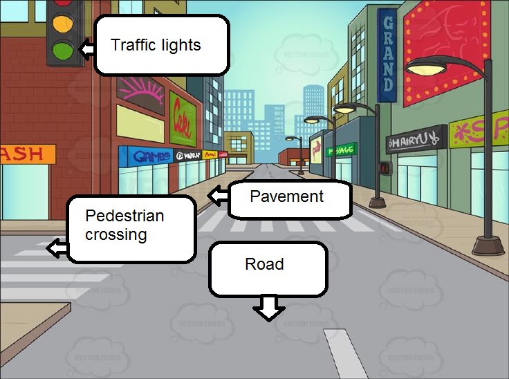
There are some safety rules we should follow in order to prevent accidents:


  1. Use the pavement.
  2. Respect the traffic lights. Cross the street when you see the green light.
  3. Use the pedestrian crossings.
  4. Fasten your seat belt.
  5. Get on and off the bus in order.

Do you know the meaning of these signs? 


Now some games:

Unit mind map:


miércoles, 26 de abril de 2017

SOCIAL SCIENCE UNIT 6: SPAIN AND ITS COMMUNITIES


CONTENIDOS:

-La población española. Características principales.
-Movimientos migratorios en España. Grupos étnicos presentes.
-Las Comunidades Autónomas: concepto y ubicación en el mapa.
-Ciudades importantes de España.

CRITERIOS DE EVALUACIÓN:

-Describe las características más importantes de la población española.
-Identifica y nombra los grupos étnicos más numerosos en España.
-Localiza en el mapa las Comunidades Autónomas principales.
-Nombra algunas ciudades importantes de España.

VOCABULARIO:
Population
Autonomous Community
Province
Migration
Immigrant
City


In Spain, there live more than 46 millions of people -this is called population. There are more women than men, and women usually live longer. More people live in cities, and less people in small villages.
Many people from different countries have come to live in Spain during the past decades. Also, many people from Spain have gone to different countries in the last few years.
Most immigrants in Spain come from Romania, Morocco, the United Kingdom and Ecuador. Spain has always had an heterogeneous population and it's important that we learn to respect others, no matter their appearance or origin.


Spain is divided into 17 Autonomous Communities and 2 Autonomous Cities: Ceuta and Melilla. Autonomous Communities are groups of provinces that share a common identity.


The most important cities in Spain are: Madrid (Comunidad de Madrid), Barcelona (Cataluña), Valencia (Comunidad Valenciana), Sevilla (Andalucía) and Zaragoza (Aragón), among others. The capital of Spain is Madrid.


Play:

Unit Mind Map:


viernes, 10 de marzo de 2017

SOCIAL SCIENCE UNIT 5: OUR CONTINENT AND COUNTRY


CONTENIDOS:

-El continente europeo: ubicación en el mapamundi.
-Países importantes de Europa y algún dato básico.
-España: forma y localización en el mapa.
-Los países fronterizos con España: Portugal, Francia y Marruecos.
-Océanos y mares que rodean la Península Ibérica.
-Islas y penínsulas: concepto y diferencias.
-Archipiélagos principales de España.

CRITERIOS DE EVALUACIÓN: 

-Señala en un mapa del mundo el continente europeo.
-Explica algunos datos fundamentales de Europa.
-Reconoce en el mapa tres países europeos: Reino Unido, Alemania y Francia.
-Ubica España y sus países limítrofes en un mapa.
-Reconoce la forma de España.
-Localiza los mares y océanos principales que bañan España.
-Ubica los archipiélagos principales de España y explica algún dato relevante sobre ellos.


VOCABULARY:

Continent
Country
Flag
Border
Peninsula
Sea
Ocean
Archipelago
Island
City


We live in Europe. It's our continent. 

There are 50 countries and more than 200 languages spoken in Europe. It is a very rich, diverse continent!

What countries can you see on the map? Can you find Spain?

Some of the most important countries in Europe are:

1. The United Kingdom. People speak English here. Its capital is London.


2. France. Poeple speak French here. Its capital is Paris.


3. Germany. People speak German here. Its capital is Berlin.


We live in Spain. The Spanish flag is red and yellow:


Spain shares borders with France and Portugal, but also with Africa (especifically, Morocco).


Spain is located in the Iberian Peninsula. A peninsula is a piece of land surrounded by water on all sides except for one.

It's bathed by the Atlantic Ocean on the West, the Cantabrian Sea on the North and the Mediterranean Sea on the East. 


Spain has two main archipelagoes. Archipelagoes are groups of islands. Islands are pieces of land surrounded by water.

The main archipelagoes in Spain are:

  • Canary Islands (Islas Canarias), with seven islands. They are in the Atlantic Ocean. Their main cities are Las Palmas de Gran Canaria and Santa Cruz de Tenerife.
  • Balearic Islands (Islas Baleares), with five islands. They are in the Mediterranean Sea. Their main city is Mallorca.

Unit Mind Map:


sábado, 21 de enero de 2017

SOCIAL SCIENCE UNIT 4: MAPS AND CONTINENTS


CONTENIDOS: 

Discriminación de tierra y agua en un mapa.
Los cinco continentes: nombre, forma y ubicación en el mapa.
Elementos del mapa: puntos cardinales, escala y simbología básica.
Países importantes del planeta: localización y datos clave.
Europa: características principales.

CRITERIOS DE EVALUACIÓN:

Señala, en un mapa físico o político, qué partes representan la tierra y el agua.
Nombra los cinco continentes.
Localiza en un mapa los cinco continentes.
Señala la ubicación de los puntos cardinales.
Comprende los símbolos de los mapas y el concepto de escala.
Identifica en un mapa algunos países importantes del mundo.
Señala Europa como el continente donde vive y explica datos fundamentales.


VOCABULARY:

Continent: continente
Border: frontera
Land: tierra
Water: agua
Compass: brújula
Compass rose: rosa de los vientos
North: norte
South: sur
East: este
West: oeste
Globe: globo terráqueo
North Pole: Polo Norte
South Pole: Polo Sur
Equator: Ecuador
Map: mapa


The Earth is a planet. It's like a big ball. Round maps of the Earth are called globes.


Globes and maps are organized by the cardinal points: North, South, East and West. We can see the cardinal points on a compass rose. We also use a compass to find out where we are!


All maps are scaled: it means the world is much bigger than the map!


The blue parts are water masses: seas, oceans, lakes and rivers. The brown parts are mountains. 


There are five continents -large land masses: America, Africa, Europe, Asia and Oceania (also called Australia). 


Here are some important countries in the world: 


In what continent is China? Asia.

In what continent are the United States? America.

In what continent is Spain? Europe.


That's right! We live in Europe. Europe is a continent with many cultures. People here speak Spanish, English, French, Russian... 


Can you recognize any monuments on the map? Let's take a closer look! This video shows some of the most important landmarks in Europe!


Unit Mind Map:


Now, some games!


domingo, 11 de diciembre de 2016

SOCIAL SCIENCE UNIT 3: THE UNIVERSE


The Universe is made of many elements: STARS, PLANETS, SATELLITES...

We live in the Solar System. Our star is the SUN and our satellite is the MOON.


MOON PHASES


viernes, 4 de noviembre de 2016

SOCIAL SCIENCE UNIT 2: LANDSCAPES


Landscapes can be inland and coastal

Inland landscapes are away from the sea. 


Coastal landscapes are close to the sea.


This is an inland landscape. It has many elements we need to know: MOUNTAIN, RIVER, WOOD, PLAIN, VILLAGE... Some are natural and some are man-made


What elements are natural? RIVER, MOUNTAIN, PLAIN, WOOD, HILL...

What elements are man-made? ROAD, BRIDGE, VILLAGE, FARM... 


A coastal landscape also has important elements: CLIFF, BEACH, SEA, ISLAND, LIGHTHOUSE... Some are natural and some are man-made


What elements are natural? ISLAND, SEA, BEACH, CLIFFS, BEACH...


What elements are man-made? LIGHTHOUSE, HARBOUR...